Flossenbürg-Plattling: Difference between revisions
From Holocaustmap
mNo edit summary |
|||
| Line 51: | Line 51: | ||
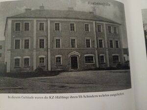
[[File:Plattling Knabenschule photograph.jpg|thumb|Photo from (as of yet) unidentified book showing the school where the [[Flossenbürg-Plattling]] concentration camp prisoners were housed.]] | [[File:Plattling Knabenschule photograph.jpg|thumb|Photo from (as of yet) unidentified book showing the school where the [[Flossenbürg-Plattling]] concentration camp prisoners were housed.]] | ||
* This location may not be accurate. More research is needed. | * This location may not be accurate. More research is needed. | ||
[https://www.openstreetmap.org/#map=16/48.776698/12.872865 48.776698/12.872865]<ref>reference</ref> | [https://www.openstreetmap.org/#map=16/48.776698/12.872865 48.776698/12.872865]<ref>reference</ref> | ||
| Line 63: | Line 63: | ||
* State: [[Bayern]] | * State: [[Bayern]] | ||
* Country: [[Germany]] | * Country: [[Germany]] | ||
== Location at or near airfield or airbase == | |||
* This location may not be accurate. More research is needed. | |||
[https://www.openstreetmap.org/#map=16/GPS GPS]<ref>reference</ref> | |||
geo: (link for navigation systems) | |||
* Street Address: [[]] | |||
* District: [[]] | |||
* Town: [[]] | |||
* State: [[]] | |||
* Country: [[]] | |||
= Organisations involved = | = Organisations involved = | ||
| Line 91: | Line 106: | ||
<!-- If there are multiple locations, copy/paste the following block and name them individually --> | <!-- If there are multiple locations, copy/paste the following block and name them individually --> | ||
=== | === Knabenschule === | ||
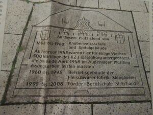
[[File:Plattling Knabenschule and concentration camp memorial tile.jpg|thumb|Plattling Knabenschule and [[Flossenbürg-Plattling]] concentration camp memorial plaque. As of yet, the exact location of this memorial is not known.]] | |||
* This location may not be accurate. More research is needed. | * This location may not be accurate. More research is needed. | ||
<!-- If there is no memorial, please add [[Category:No Memorial]] at the end of the page and remove the following lines --> | <!-- If there is no memorial, please add [[Category:No Memorial]] at the end of the page and remove the following lines --> | ||
[https://www.openstreetmap.org/#map=16/ | [https://www.openstreetmap.org/#map=16/48.776698/12.872865 48.776698/12.872865] | ||
geo: (link for navigation systems) | geo:12.872865,48.776698 (link for navigation systems) | ||
* Street Address: [[]] | * Street Address: [[Preysingplatz]] 2 | ||
* District: [[]] | * District: [[]] | ||
* Town: [[]] | * Town: [[Plattling]] | ||
* State: [[]] | * State: [[Bayern]] | ||
* Country: [[]] | * Country: [[Germany]] | ||
= Description = | = Description = | ||
| Line 150: | Line 165: | ||
<!-- | <!-- | ||
[[Category:No Memorial]] | [[Category:No Memorial]] | ||
--> | |||
[[Category:Location Unknown]] | [[Category:Location Unknown]] | ||
== Sources == | == Sources == | ||
<!-- Leave this empty --> | <!-- Leave this empty --> | ||
Revision as of 05:59, 3 August 2025
Names
Type
Dates
(YYYY-MM-DD)
- Opened: 1945-02-20
- Closed: 1945-04-25
Internal and external work details and, if applicable, (known) subcamps
Internal work details (Kommando)
External work details (Aussenkommando)
- The subcamp’s prisoners were used primarily in constructing the bunkers. At the same time, they were used to remove bomb damage in the surrounding towns, and sometimes they worked on farms[6]
- Historian Michael Westerholz also states that the prisoners were used to build an aircraft base at Hettenkofen, construction of which had begun in March 1944.[7]
Subcamps (Aussenlager)
Locations
Knabenschule Plattling

- This location may not be accurate. More research is needed.
geo:12.872927,48.776621 (link for navigation systems)
- Street Address: Preysingplatz 2
- District: [[]]
- Town: Plattling
- State: Bayern
- Country: Germany
Location at or near airfield or airbase
- This location may not be accurate. More research is needed.
geo: (link for navigation systems)
- Street Address: [[]]
- District: [[]]
- Town: [[]]
- State: [[]]
- Country: [[]]
Organisations involved
- [[]]
Victims and Survivors
Population information
Names of victims
Names of survivors
Location of graves
Staff
This camp was run by the SS-WVHA, Luftwaffe, Organisation Todt, Volkssturm, Wehrmacht
Names of perpetrators and any other people involved
Current status
Status of the site
Accessibility
Memorials
Knabenschule

- This location may not be accurate. More research is needed.
geo:12.872865,48.776698 (link for navigation systems)
- Street Address: Preysingplatz 2
- District: [[]]
- Town: Plattling
- State: Bayern
- Country: Germany
Description
Resources
Bibliography
Links
- https://www.gedenkstaette-flossenbuerg.de/de/geschichte/aussenlager/plattling
- https://www.hagalil.com/2025/01/plattling/
Custodians
Outstanding questions
- However, this was not the first group of prisoners to arrive in Plattling: concentration camp prisoners had been used since March 1944 by the Organisation Todt (OT) Bauleitung (Construction Management) and the Klug company on the nearby airfield, mostly in the construction of roads.[10] Where did they come from and where were they housed, further information, etcetera?
Discrepancies and errata
Sources
- ↑ United States Holocaust Memorial Museum Encyclopedia Volume I: part A page 652
- ↑ Das Nationalsozialistische Lagersystem, (CCP), page 205
- ↑ Verzeichnis der Haftstätten unter dem Reichsführer-SS 1933-1945, page 116
- ↑ Die nationalsozialistischen Lager, page 194
- ↑ https://www.gedenkstaette-flossenbuerg.de/de/geschichte/aussenlager/plattling
- ↑ United States Holocaust Memorial Museum Encyclopedia Volume I: part A page 652
- ↑ United States Holocaust Memorial Museum Encyclopedia Volume I: part A page 652
- ↑ reference
- ↑ reference
- ↑ United States Holocaust Memorial Museum Encyclopedia Volume I: part A page 652