Flossenbürg-Lobositz: Difference between revisions
From Holocaustmap
mNo edit summary |
mNo edit summary |
||
| Line 60: | Line 60: | ||
* Country: [[Czechia]] | * Country: [[Czechia]] | ||
=== Police prison in court building === | |||
* This location may not be accurate. More research is needed. | |||
* This location may not be accurate. More research is needed. (The actual location inside the building) | |||
[https://www.openstreetmap.org/#map=16/ | |||
[https://www.openstreetmap.org/#map=16/50.514332/14.048840 50.514332/14.048840]<ref>reference</ref> | |||
geo: (link for navigation systems) | geo: (link for navigation systems) | ||
| Line 146: | Line 147: | ||
== Discrepancies and errata == | == Discrepancies and errata == | ||
<!-- Information, including location information, that differs between sources is recorded here. Name the source and the discrepancy and, if possible, reasoning for the discrepancies. --> | <!-- Information, including location information, that differs between sources is recorded here. Name the source and the discrepancy and, if possible, reasoning for the discrepancies. --> | ||
* | * The GPS coordinates given by the Flossenbürg memorial site point to 50.515042, 14.051041 (Školní 41/1, 410 02 Lovosice 2), whereas the old court building in the photograph is actually at 50.513809, 14.166277 (355/2, Sady pionýrů, Lovosice) | ||
* | * | ||
Revision as of 17:31, 22 January 2025
Names
Type
Dates
(YYYY-MM-DD)
- Opened:
- Closed:
Internal and external work details and, if applicable, (known) subcamps
Internal work details (Kommando)
External work details (Aussenkommando)
Subcamps (Aussenlager)
Locations
Camp location
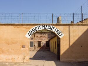
Gestapo prison, Kleine Festung, Theresienstadt

- This location may not be accurate. More research is needed.
geo:50.513809,14.166277 (link for navigation systems)
Police prison in court building
- This location may not be accurate. More research is needed. (The actual location inside the building)
geo: (link for navigation systems)
- Street Address: [[]]
- District: [[]]
- Town: [[]]
- State: [[]]
- Country: [[]]
Organisations involved
- [[]]
Victims and Survivors
Population information
Names of victims
Names of survivors
Location of graves
Staff
This camp was run by the SS-WVHA/Gestapo/Wehrmacht/DAF/OT
Names of perpetrators and any other people involved
Current status
Status of the site
Accessibility
Memorials
Memorial location
geo: (link for navigation systems)
- Street Address: [[]]
- District: [[]]
- Town: [[]]
- State: [[]]
- Country: [[]]
No memorial known at this time.
Description
Outstanding questions
Resources
Bibliography
- United States Holocaust Memorial Museum Encyclopedia Volume I: part A page 630
- Das Nationalsozialistische Lagersystem, (CCP), page 43
- Verzeichnis der Haftstätten unter dem Reichsführer-SS 1933-1945, page 113
- Supreme headquarters allied expeditionary force, The German concentration camps, page D5
Links
Custodians
Outstanding questions
Discrepancies and errata
- The GPS coordinates given by the Flossenbürg memorial site point to 50.515042, 14.051041 (Školní 41/1, 410 02 Lovosice 2), whereas the old court building in the photograph is actually at 50.513809, 14.166277 (355/2, Sady pionýrů, Lovosice)
Sources
- ↑ United States Holocaust Memorial Museum Encyclopedia Volume I: part A page 630
- ↑ Das Nationalsozialistische Lagersystem, (CCP), page 43
- ↑ Verzeichnis der Haftstätten unter dem Reichsführer-SS 1933-1945, page 113
- ↑ Supreme headquarters allied expeditionary force, The German concentration camps, page D5
- ↑ Das Nationalsozialistische Lagersystem, (CCP), page 43
- ↑ United States Holocaust Memorial Museum Encyclopedia Volume I: part A page 626
- ↑ reference