Flossenbürg-Stulln: Difference between revisions
From Holocaustmap
mNo edit summary |
|||
| Line 101: | Line 101: | ||
--> | --> | ||
<!-- If there is no memorial, please add [[Category:No Memorial]] at the end of the page and remove the following lines --> | <!-- If there is no memorial, please add [[Category:No Memorial]] at the end of the page and remove the following lines --> | ||
No memorial known at this time. | No memorial known at this time. | ||
Latest revision as of 07:36, 16 August 2025
Names
Type
Dates
(YYYY-MM-DD)
- Opened: 1942-02
- Closed: 1942-10
Internal and external work details and, if applicable, (known) subcamps
Internal work details (Kommando)
External work details (Aussenkommando)
Subcamps (Aussenlager)
Locations
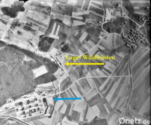
Waldfrieden-Lager

- This location may not be accurate. More research is needed.
geo:12.149412,49.422976 (link for navigation systems)
- Street Address: Sportplatzweg 4
- District: [[]]
- Town: Schwandorf
- State: Bayern
- Country: Germany
Organisations involved
Victims and Survivors
Population information
Names of victims
Names of survivors
Location of graves
Staff
This camp was run by the SS-WVHA
Names of perpetrators and any other people involved
Current status
Status of the site
Accessibility
Memorials
Memorial location
No memorial known at this time.
Description
Stulln was the first subcamp of the Flossenbürg concentration camp system.[7]
Resources
Bibliography
- Der Ort des Terrors,Band 4, page 261
- United States Holocaust Memorial Museum Encyclopedia Volume I: part A page 673
- Die nationalsozialistischen Lager, page 194
Links
- https://www.gedenkstaette-flossenbuerg.de/de/geschichte/aussenlager/stulln
- https://www.onetz.de/oberpfalz/stulln/80-jahren-kamen-ersten-kz-haeftlinge-flossenbuerg-ins-aussenlager-stulln-id3408207.html
Custodians
Outstanding questions
- The prisoners were also forced to work for other companies via the Arbeitsamt Weiden[8]. More research is needed.
- Some of the buildings built by prisonrs are still standing. It would be good to document them. More research is needed.
Discrepancies and errata
- Das Nationalsozialistische Lagersystem, (CCP) does not contain an entry for this Flossenbürg subcamp, the only location mentioned is the Zivilarbeiterlager in Stulln on page 215. The company mentioned here is "Vereinigte Flusspatgruben GmbH".
Sources
- ↑ Der Ort des Terrors,Band 4, page 261
- ↑ Die nationalsozialistischen Lager, page 194
- ↑ United States Holocaust Memorial Museum Encyclopedia Volume I: part A page 673
- ↑ Verzeichnis der Haftstätten unter dem Reichsführer-SS 1933-1945, page 121
- ↑ https://www.gedenkstaette-flossenbuerg.de/de/geschichte/aussenlager/stulln
- ↑ https://www.onetz.de/oberpfalz/stulln/80-jahren-kamen-ersten-kz-haeftlinge-flossenbuerg-ins-aussenlager-stulln-id3408207.html
- ↑ United States Holocaust Memorial Museum Encyclopedia Volume I: part A page 673
- ↑ Der Ort des Terrors, page 263