Flossenbürg-Königstein: Difference between revisions
From Holocaustmap
mNo edit summary |
m (→Links) |
||
| (8 intermediate revisions by the same user not shown) | |||
| Line 38: | Line 38: | ||
== External work details (''Aussenkommando'') == | == External work details (''Aussenkommando'') == | ||
* "Steinbruch", see the map below. | |||
== Subcamps (''Aussenlager'') == | == Subcamps (''Aussenlager'') == | ||
| Line 50: | Line 51: | ||
== Camp location == | == Camp location == | ||
=== Struppen === | === Struppen === | ||
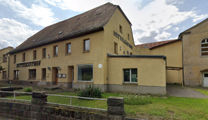
[[File:Königstein Struppen Mittelgasthof.png|thumb|[[Flossenbürg-Königstein]] concentration camp in the Struppen "Mittelgasthof".]] | |||
* ''Initially they were housed in the inn of the neighboring city Struppen and had to erect a provisional camp out of pressed cardboard, the so-called round Finnish tents, within the Königstein Fortress.''<ref>[[United States Holocaust Memorial Museum Encyclopedia]] Volume I: part A page 624</ref> | * ''Initially they were housed in the inn of the neighboring city Struppen and had to erect a provisional camp out of pressed cardboard, the so-called round Finnish tents, within the Königstein Fortress.''<ref>[[United States Holocaust Memorial Museum Encyclopedia]] Volume I: part A page 624</ref> | ||
[https://www.openstreetmap.org/#map=16/ | [https://www.openstreetmap.org/#map=16/50.935361/14.009408 50.935361/14.009408]<ref>https://www.gedenkplaetze.info/widerstand/mittelgasthof-struppen</ref> | ||
geo: (link for navigation systems) | geo:50.935361,14.009408 (link for navigation systems) | ||
* Street Address: [[]] | * Street Address: [[Hauptstraße]] 52 | ||
* District: [[]] | * District: [[]] | ||
* Town: [[]] | * Town: [[Struppen]] | ||
* State: [[]] | * State: [[Sachsen]] | ||
* Country: [[]] | * Country: [[Germany]] | ||
=== Festung Königstein === | === Festung Königstein === | ||
* This location may not be accurate. More research is needed. | * This location may not be accurate. More research is needed. | ||
[https://www.openstreetmap.org/#map=16/50.919079/14.057103 50.919079/14.057103] | [https://www.openstreetmap.org/#map=16/50.919079/14.057103 50.919079/14.057103]<ref>[[United States Holocaust Memorial Museum Encyclopedia]] Volume I: part A page 623</ref> | ||
geo:50.919079,14.057103 (link for navigation systems) | geo:50.919079,14.057103 (link for navigation systems) | ||
| Line 78: | Line 79: | ||
=== "further into the forest" === | === "further into the forest" === | ||
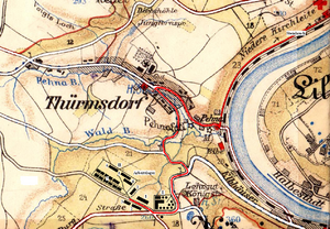
[[File:Königstein map.PNG|thumb|Map showing [[Flossenbürg-Königstein]], forced labour camp and subcamp of [[Flossenbürg]]]] | |||
* ''the prisoners were thus moved further into the forest to a barracks camp, which was fenced in with barbed wire, equipped with watchtowers, and consisted of 10 prisoner barracks, a kitchen, and an infirmary.''<ref>[[United States Holocaust Memorial Museum Encyclopedia]] Volume I: part A page 624</ref> | * ''the prisoners were thus moved further into the forest to a barracks camp, which was fenced in with barbed wire, equipped with watchtowers, and consisted of 10 prisoner barracks, a kitchen, and an infirmary.''<ref>[[United States Holocaust Memorial Museum Encyclopedia]] Volume I: part A page 624</ref> | ||
* This location may not be accurate. More research is needed. | * This location may not be accurate. More research is needed. | ||
[https://www.openstreetmap.org/#map=16/ | [https://www.openstreetmap.org/#map=16/50.921612/14.045007 50.921612/14.045007]<ref>https://de.wikipedia.org/wiki/Schwalbe_II_(K%C3%B6nigstein)</ref> | ||
geo: (link for navigation systems) | geo:50.921612,14.045007 (link for navigation systems) | ||
* Street Address: [[]] | * Street Address: [[Burgstraße]] | ||
* District: [[]] | * District: [[]] | ||
* Town: [[]] | * Town: [[Königstein]] | ||
* State: [[]] | * State: [[Sachsen]] | ||
* Country: [[]] | * Country: [[Germany]] | ||
= Organisations involved = | = Organisations involved = | ||
| Line 106: | Line 108: | ||
= Staff = | = Staff = | ||
== This camp was run by the [[:Category:SS-WVHA|SS-WVHA]] | == This camp was run by the [[:Category:SS-WVHA|SS-WVHA]] == | ||
== Names of perpetrators and any other people involved == | == Names of perpetrators and any other people involved == | ||
| Line 152: | Line 154: | ||
== Links == | == Links == | ||
<!-- Related websites and other links --> | <!-- Related websites and other links --> | ||
* | * https://www.gedenkstaette-flossenbuerg.de/de/geschichte/aussenlager/koenigstein | ||
== Custodians == | == Custodians == | ||
| Line 169: | Line 171: | ||
[[Category:SS-WVHA]] | [[Category:SS-WVHA]] | ||
[[Category:Flossenbürg]] | [[Category:Flossenbürg]] | ||
[[Category: | [[Category:Königstein]] | ||
[[Category: | [[Category:Sachsen]] | ||
[[Category:Germany]] | [[Category:Germany]] | ||
[[Category:Organisation Todt]] | [[Category:Organisation Todt]] | ||
Latest revision as of 05:25, 16 January 2025
Names
- Königstein[1][2]
- Koenigstein/Elbe[3]
- Außenlager Königstein[4]
- Schwalbe II[5]
- Orion[6]
- Rathen-Schwalbe[7]
Type
Dates
(YYYY-MM-DD)
- Opened: 1944-11-15 (transport of 200 men from Buchenwald-Böhlen
- Closed:
List of (known) subcamps, internal and external work details
Internal work details (Kommando)
External work details (Aussenkommando)
- "Steinbruch", see the map below.
Subcamps (Aussenlager)
Locations
Camp location
Struppen

- Initially they were housed in the inn of the neighboring city Struppen and had to erect a provisional camp out of pressed cardboard, the so-called round Finnish tents, within the Königstein Fortress.[8]
geo:50.935361,14.009408 (link for navigation systems)
- Street Address: Hauptstraße 52
- District: [[]]
- Town: Struppen
- State: Sachsen
- Country: Germany
Festung Königstein
- This location may not be accurate. More research is needed.
geo:50.919079,14.057103 (link for navigation systems)
- Street Address: [[]]
- District: [[]]
- Town: Königstein
- State: Sachsen
- Country: Germany
"further into the forest"

- the prisoners were thus moved further into the forest to a barracks camp, which was fenced in with barbed wire, equipped with watchtowers, and consisted of 10 prisoner barracks, a kitchen, and an infirmary.[11]
- This location may not be accurate. More research is needed.
geo:50.921612,14.045007 (link for navigation systems)
- Street Address: Burgstraße
- District: [[]]
- Town: Königstein
- State: Sachsen
- Country: Germany
Organisations involved
Victims and Survivors
Population information
Names of victims
Names of survivors
Location of graves
Staff
This camp was run by the SS-WVHA
Names of perpetrators and any other people involved
Current status
Status of the site
Accessibility
Memorials
Memorial location
geo: (link for navigation systems)
- Street Address: [[]]
- District: [[]]
- Town: [[]]
- State: [[]]
- Country: [[]]
No memorial known at this time.
Description
Outstanding questions
Resources
Bibliography
- United States Holocaust Memorial Museum Encyclopedia Volume I: part A page 623
- Das Nationalsozialistische Lagersystem, (CCP), page 237
- Verzeichnis der Haftstätten unter dem Reichsführer-SS 1933-1945, page 111
Links
Custodians
Sources
- ↑ United States Holocaust Memorial Museum Encyclopedia Volume I: part A page 623
- ↑ Verzeichnis der Haftstätten unter dem Reichsführer-SS 1933-1945, page 111
- ↑ Das Nationalsozialistische Lagersystem, (CCP), page 237
- ↑ https://www.gedenkstaette-flossenbuerg.de/de/geschichte/aussenlager/koenigstein
- ↑ Das Nationalsozialistische Lagersystem, (CCP), page 237
- ↑ Das Nationalsozialistische Lagersystem, (CCP), page 237
- ↑ Verzeichnis der Haftstätten unter dem Reichsführer-SS 1933-1945, page 111
- ↑ United States Holocaust Memorial Museum Encyclopedia Volume I: part A page 624
- ↑ https://www.gedenkplaetze.info/widerstand/mittelgasthof-struppen
- ↑ United States Holocaust Memorial Museum Encyclopedia Volume I: part A page 623
- ↑ United States Holocaust Memorial Museum Encyclopedia Volume I: part A page 624
- ↑ https://de.wikipedia.org/wiki/Schwalbe_II_(K%C3%B6nigstein)