Flossenbürg-Holleischen: Difference between revisions
From Holocaustmap
mNo edit summary |
mNo edit summary |
||
| (3 intermediate revisions by the same user not shown) | |||
| Line 88: | Line 88: | ||
=== Memorial location === | === Memorial location === | ||
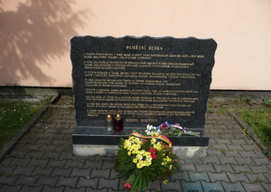
[[File:Holleischen Memorial.png|thumb|Memorial for the [[Flossenbürg-Holleischen|Holleischen]], forced labour camp and subcamp of [[Flossenbürg]]]] | |||
<!-- | <!-- | ||
* This location may not be accurate. More research is needed. | * This location may not be accurate. More research is needed. | ||
--> | --> | ||
<!-- If there is no memorial, please add [[Category:No Memorial]] at the end of the page and remove the following lines --> | <!-- If there is no memorial, please add [[Category:No Memorial]] at the end of the page and remove the following lines --> | ||
[https://www.openstreetmap.org/#map=16/ | [https://www.openstreetmap.org/#map=16/49.606081/13.098780 49.606081/13.098780] | ||
geo: (link for navigation systems) | geo:49.606081,13.098780 (link for navigation systems) | ||
* Street Address: [[]] | * Street Address: [[Politických vězňů]] | ||
* District: [[]] | * District: [[]] | ||
* Town: [[]] | * Town: [[Holýšov]] | ||
* State: [[]] | * State: [[Plzeň Region]] | ||
* Country: [[]] | * Country: [[Czechia]] | ||
[https://www.openstreetmap.org/relation/6453901#map=16/49.60178/13.09789 An informational path] | |||
= Description = | = Description = | ||
| Line 110: | Line 111: | ||
<!-- Any questions that need answering to improve the quality of this page --> | <!-- Any questions that need answering to improve the quality of this page --> | ||
* The location for "Werk II" is currently not known. There are several bunkers from the late 1930s around this area, in the forest: https://www.openstreetmap.org/node/3371970719 . See also https://ropiky.net/dbase_objekt.php?id=1075721612 for more information | * The location for "Werk II" is currently not known. There are several bunkers from the late 1930s around this area, in the forest: https://www.openstreetmap.org/node/3371970719 . See also https://ropiky.net/dbase_objekt.php?id=1075721612 for more information | ||
* [https://www.openstreetmap.org/relation/6453901#map=16/49.60178/13.09789 This informational path] with several information boards may be useful to find more information about the locations of this concentration camp. | |||
= Resources = | = Resources = | ||
| Line 142: | Line 144: | ||
<!-- | <!-- | ||
[[Category:No Memorial]] | [[Category:No Memorial]] | ||
--> | |||
[[Category:Location Unknown]] | [[Category:Location Unknown]] | ||
== Sources == | == Sources == | ||
<!-- Leave this empty --> | <!-- Leave this empty --> | ||
Latest revision as of 16:50, 3 January 2025
Names
Type
Dates
(YYYY-MM-DD)
- Opened:
- Closed:
List of (known) subcamps, internal and external work details
Internal work details (Kommando)
External work details (Aussenkommando)
- Werk II, "located in a forest outside the village
Subcamps (Aussenlager)
Locations
Camp location
geo:49.605992,13.098153 (link for navigation systems)
- Street Address: Politických vězňů 293
- District: [[]]
- Town: [[]]
- State: Plzeň Region
- Country: Czechia
Organisations involved
Victims and Survivors
Population information
Names of victims
Names of survivors
Location of graves
Staff
This camp was run by the SS-WVHA/Gestapo/Wehrmacht/DAF/OT
Names of perpetrators and any other people involved
Current status
Status of the site
Accessibility
Memorials
Memorial location

geo:49.606081,13.098780 (link for navigation systems)
- Street Address: Politických vězňů
- District: [[]]
- Town: Holýšov
- State: Plzeň Region
- Country: Czechia
Description
Outstanding questions
- The location for "Werk II" is currently not known. There are several bunkers from the late 1930s around this area, in the forest: https://www.openstreetmap.org/node/3371970719 . See also https://ropiky.net/dbase_objekt.php?id=1075721612 for more information
- This informational path with several information boards may be useful to find more information about the locations of this concentration camp.
Resources
Bibliography
Links
Custodians
Sources
- ↑ United States Holocaust Memorial Museum Encyclopedia Volume I: part A page 614
- ↑ Verzeichnis der Haftstätten unter dem Reichsführer-SS 1933-1945, page 109
- ↑ Das Nationalsozialistische Lagersystem, (CCP), page 41
- ↑ Supreme headquarters allied expeditionary force, The German concentration camps, page D12
- ↑ https://www.gedenkstaette-flossenbuerg.de/de/geschichte/aussenlager/holleischen