Dachau-Augsburg-Pfersee: Difference between revisions
From Holocaustmap
mNo edit summary |
|||
| Line 37: | Line 37: | ||
=== Memorial === | === Memorial === | ||
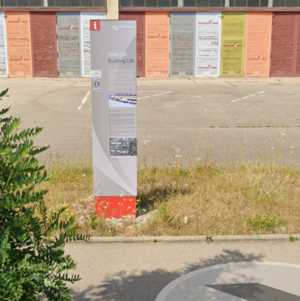
[[File:Screenshot 2024-05-10 at 18-43-57 48°07'32.0 N 16°32'25.3 E · Wien-Flughafen 1300 Schwechat Austria.png|thumb|Memorial Halle 116, Augsburg]] | |||
<!-- If there is no memorial, please add [[Category:No Memorial]] at the end of the page and remove the following lines --> | <!-- If there is no memorial, please add [[Category:No Memorial]] at the end of the page and remove the following lines --> | ||
[https://www.openstreetmap.org/#map=16/48.35993/10.85352 48.35993/10.85352]<ref>reference</ref> | [https://www.openstreetmap.org/#map=16/48.35993/10.85352 48.35993/10.85352]<ref>reference</ref> | ||
| Line 44: | Line 45: | ||
* State: [[Bayern]] | * State: [[Bayern]] | ||
* Country: [[Deutschland]] | * Country: [[Deutschland]] | ||
== Population == | == Population == | ||
Revision as of 16:49, 10 May 2024
Names
Type
List of (known) subcamps
Dates
- Opened:
- Closed:
Locations
Camp
- Street Address: Karl-Nolan-Strasse
- District: Adelbert-Stifter-Siedlung
- Town: Augsburg
- State: Bayern
- Country: Deutschland
Memorial

- Street Address: Karl-Nolan-Strasse
- District: Adelbert-Stifter-Siedlung
- Town: Augsburg
- State: Bayern
- Country: Deutschland
Population
Company Names
[[]]
Victims and Survivors
Names of victims and survivors, if these are known.
Staff
This camp was run by the SS/Gestapo/Wehrmacht.
Names of SS and other people involved in the exploitation, including convictions where applicable.