Lager Höherweg: Difference between revisions
From Holocaustmap
mNo edit summary |
|||
| (4 intermediate revisions by the same user not shown) | |||
| Line 33: | Line 33: | ||
Memorial: [https://www.openstreetmap.org/#map=16/51.21995/6.83978 51.21995/6.83978]<ref>https://www.wikiwand.com/de/Lierenfeld#Media/Datei:D%C3%BCsseldorf-Lierenfeld_Gedenktafel.JPG</ref> | Memorial: [https://www.openstreetmap.org/#map=16/51.21995/6.83978 51.21995/6.83978]<ref>https://www.wikiwand.com/de/Lierenfeld#Media/Datei:D%C3%BCsseldorf-Lierenfeld_Gedenktafel.JPG</ref> | ||
Memorial: [https://www.openstreetmap.org/#map=16/51.22470/6.77090 51.22470/6.77090]<ref>https://www.google.com/maps/place/Ehra+oder+Kind+mit+Ball/@51.2247077,6.7713024,20z/data=!4m6!3m5!1s0x47b8ca1759b4bb91:0xd2bf083c30d6b455!8m2!3d51.224647!4d6.7709718!16s%2Fg%2F121tb9yw?entry=ttu</ref> | Memorial ''Ehra oder Kind mit Ball'': [https://www.openstreetmap.org/#map=16/51.22470/6.77090 51.22470/6.77090]<ref>https://www.google.com/maps/place/Ehra+oder+Kind+mit+Ball/@51.2247077,6.7713024,20z/data=!4m6!3m5!1s0x47b8ca1759b4bb91:0xd2bf083c30d6b455!8m2!3d51.224647!4d6.7709718!16s%2Fg%2F121tb9yw?entry=ttu</ref> | ||
== Population == | == Population == | ||
| Line 52: | Line 52: | ||
[[File:Screenshot 2024-04-26 at 22-11-39 Google Maps.png]] | [[File:Screenshot 2024-04-26 at 22-11-39 Google Maps.png]] | ||
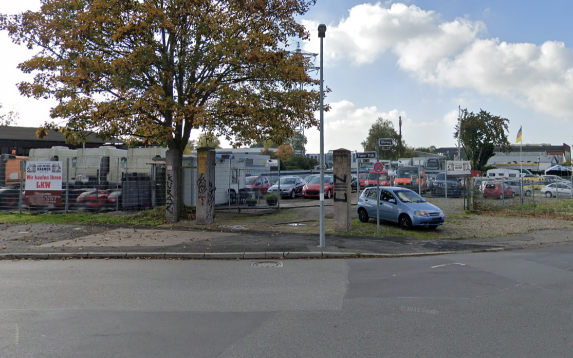
Corner of Höherweg and Posener Strasse. Potentially the entrance of the camp for Roma and Sinti that was located on the Höherweg. Right behind, on the train viaduct, is the memorial for the camp. More research is needed. | Corner of Höherweg and Posener Strasse. Potentially the entrance of the camp for Roma and Sinti that was located on the Höherweg. Right behind, on the train viaduct, is the memorial for the camp. More research is needed. | ||
<!-- Change the categories below to fit this camp --> | <!-- Change the categories below to fit this camp --> | ||
[[Category:Camp for Roma and Sinti]] | [[Category:Camp for Roma and Sinti]] | ||
[[Category:Internment camp]] | |||
[[Category:Porajmos]] | [[Category:Porajmos]] | ||
[[Category:Düsseldorf]] | [[Category:Düsseldorf]] | ||
[[Category:Deutschland]] | [[Category:Deutschland]] | ||
[[Category: | |||
[[Category:Location Unknown]] | |||
[[Category:Needs more research]] | |||
Latest revision as of 13:09, 12 September 2025
Names
Lager Höherweg Internierungslager Höherweg Düsseldorf Höherweg
Type
List of (known) subcamps
Dates
- Opened: July 1937
- Closed: March 1945[1]
Location
Camp: 51.21996/6.83919[2]
- Street Address: Höherweg / Posener Strasse
- District: Lierenfeld Stadtbezirk 8
- Town: Düsseldorf
- State: Nordrhein-Westfalen
- Country: Deutschland
Memorial: 51.21995/6.83978[3]
Memorial Ehra oder Kind mit Ball: 51.22470/6.77090[4]
Population
Company Names
[[]]
Victims and Survivors
Names of victims and survivors, if these are known.
Staff
This camp was run by the SS/Gestapo/Wehrmacht.
Names of SS and other people involved in the exploitation, including convictions where applicable.
Description
Corner of Höherweg and Posener Strasse. Potentially the entrance of the camp for Roma and Sinti that was located on the Höherweg. Right behind, on the train viaduct, is the memorial for the camp. More research is needed.
- ↑ http://www.tenhumbergreinhard.de/1933-1945-lager-1/1933-1945-lager-d/duesseldorf-hoeherweg.html
- ↑ reference
- ↑ https://www.wikiwand.com/de/Lierenfeld#Media/Datei:D%C3%BCsseldorf-Lierenfeld_Gedenktafel.JPG
- ↑ https://www.google.com/maps/place/Ehra+oder+Kind+mit+Ball/@51.2247077,6.7713024,20z/data=!4m6!3m5!1s0x47b8ca1759b4bb91:0xd2bf083c30d6b455!8m2!3d51.224647!4d6.7709718!16s%2Fg%2F121tb9yw?entry=ttu
