Flossenbürg-Dresden (Reichsbahn): Difference between revisions
From Holocaustmap
mNo edit summary |
mNo edit summary |
||
| (4 intermediate revisions by the same user not shown) | |||
| Line 40: | Line 40: | ||
== Camp location == | == Camp location == | ||
* This location may not be accurate. More research is needed. | * This location may not be accurate. More research is needed. | ||
[https://www.openstreetmap.org/#map=16/51.060693/13.690648 51.060693/13.690648]<ref>[[United States Holocaust Memorial Museum Encyclopedia]] I-A page 589</ref><ref>https://www.gedenkstaette-flossenbuerg.de/de/geschichte/aussenlager/dresden-reichsbahn</ref> | |||
[https://www.openstreetmap.org/#map=16/ | |||
geo: (link for navigation systems) | geo:51.060693,13.690648 (link for navigation systems) | ||
* Street Address: [[]] | * Street Address: [[Flügelweg]] | ||
* District: [[]] | * District: [[Friedrichstadt]] | ||
* Town: [[]] | * Town: [[Dresden]] | ||
* State: [[]] | * State: [[Sachsen]] | ||
* Country: [[]] | * Country: [[Germany]] | ||
= Organisations involved = | = Organisations involved = | ||
| Line 73: | Line 71: | ||
== Names of perpetrators and any other people involved == | == Names of perpetrators and any other people involved == | ||
<!-- Including convictions where applicable. --> | <!-- Including convictions where applicable. --> | ||
* [[SS-Hauptscharführer]] [[Franz Rohloff]] | |||
= Current status = | = Current status = | ||
| Line 78: | Line 77: | ||
== Accessibility == | == Accessibility == | ||
== Memorials == | |||
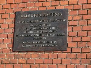
[[File:Gedenktafel Emerich-Ambros-Ufer Friedrichstadt 1.JPG|thumb|Memorial for [[Emerich Ambros]], Hungarian freedom fighter, on the west facing side of the building.]] | |||
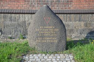
[[File:Emerich-Ambros-Ufer Gedenkstein.jpg|thumb|Memorial for the victims of the [[Flossenbürg-Dresden-Friedrichstadt (RAW)]] forced labour concentration camp.]] | |||
<!-- If there is no memorial, please add [[Category:No Memorial]] at the end of the page and remove the following lines --> | <!-- If there is no memorial, please add [[Category:No Memorial]] at the end of the page and remove the following lines --> | ||
[https://www.openstreetmap.org/#map=16/ | [https://www.openstreetmap.org/#map=16/51.052699/13.698728 51.052699/13.698728] | ||
geo:51.052699,13.698728 (link for navigation systems) | |||
* Street Address: [[Emmerich-Ambros-Ufer]] 50 | |||
* District: [[Friedrichstadt]] | |||
* Town: [[Dresden]] | |||
* State: [[Sachsen]] | |||
* Country: [[Germany]] | |||
= Description = | = Description = | ||
| Line 126: | Line 129: | ||
[[Category:Reichsbahnausbesserungswerk]] | [[Category:Reichsbahnausbesserungswerk]] | ||
[[Category:Location Unknown]] | [[Category:Location Unknown]] | ||
== Sources == | == Sources == | ||
<!-- Leave this empty --> | <!-- Leave this empty --> | ||
Latest revision as of 14:39, 13 December 2024
Names
Type
Dates
(YYYY-MM-DD)
- Opened:
- Closed:
List of (known) subcamps, internal and external work details
Internal work details (Kommando)
External work details (Aussenkommando)
Subcamps (Aussenlager)
Locations
Camp location
- This location may not be accurate. More research is needed.
geo:51.060693,13.690648 (link for navigation systems)
- Street Address: Flügelweg
- District: Friedrichstadt
- Town: Dresden
- State: Sachsen
- Country: Germany
Organisations involved
Victims and Survivors
Population information
Names of victims
Names of survivors
Location of graves
Staff
This camp was run by the SS-WVHA/Gestapo/Wehrmacht/DAF/OT
Names of perpetrators and any other people involved
Current status
Status of the site
Accessibility
Memorials


geo:51.052699,13.698728 (link for navigation systems)
- Street Address: Emmerich-Ambros-Ufer 50
- District: Friedrichstadt
- Town: Dresden
- State: Sachsen
- Country: Germany
Description
Outstanding questions
Resources
Bibliography
Links
Custodians